Lake Malawi (Lake Nyasa)-NASAFlickr.jpg: Porovnání verzí
Jump to navigation
Jump to search
m (Nahrazení textu „== Popis ==↵GIGA08.11.2025“ textem „“) |
(++) |
||
| (Není zobrazena jedna mezilehlá verze od stejného uživatele.) | |||
| Řádek 1: | Řádek 1: | ||
GIGANTICKÁ Fotografie + English: Lake Malawi (Lake Nyasa) (Uploaded on July 2, 2016) | |||
* This low-oblique, southeast-looking photograph taken during the [[STS-61]] mission shows Lake Malawi, one of many elongated lakes that form part of the Great Rift Valley of east Africa. The lake, bounded by steep mountains on all sides except the southern end, is approximately 360 miles (580 kilometers) long, averages 25 miles (40 kilometers) in width, and has a maximum depth of 2,316 feet (706 meters). Lake Malawi is drained at the south end by the Shire River, which eventually empties into the Zambezi River. The lake and its steep-sloped shoreline were created by faulting that caused a thrust upward as the valley floor subsided between the slopes. The darker area along the northwest coast of the lake is the Nyika Plateau, which has several elevations more than 8,000 feet (2,440 meters) above sea level. Landlocked Malawi extends along the entire west coast of the lake. The large Luangwa River basin is visible as it drains to the southwest. Immediately west of the Luangwa River Valley stand the northeast-southwest-trending Muchinga Mountains with their dark ridgeline and maximum elevations reaching 6,000 feet (1,830 meters) above sea level. Northwest of this mountain range, drainage is to the north and west into the much larger Zaire (Congo) River watershed. | |||
* Author: '''NASA Hubble Space Telescope''' | |||
+ pochází z Flickr.com, kde má status – Creative Commons Attribution 2.0 Generic (CC BY 2.0) | |||
FLICKR – https://www.flickr.com/photos/nasahubble/27410005594/ | |||
[[Kategorie:CC fotografie]] | |||
[[Kategorie:Gigantické fotografie]] | |||
[[Kategorie:NASA images]] | |||
[[Kategorie:Hubble images]] | |||
-NASAFlickr.jpg&oldid=4093)
-NASAFlickr.jpg&action=edit&oldid=4093)
-NASAFlickr.jpg&diff=prev&oldid=4093)
-NASAFlickr.jpg&oldid=4480)
-NASAFlickr.jpg&action=edit)
Aktuální verze z 15. 11. 2025, 15:24
GIGANTICKÁ Fotografie + English: Lake Malawi (Lake Nyasa) (Uploaded on July 2, 2016)
- This low-oblique, southeast-looking photograph taken during the STS-61 mission shows Lake Malawi, one of many elongated lakes that form part of the Great Rift Valley of east Africa. The lake, bounded by steep mountains on all sides except the southern end, is approximately 360 miles (580 kilometers) long, averages 25 miles (40 kilometers) in width, and has a maximum depth of 2,316 feet (706 meters). Lake Malawi is drained at the south end by the Shire River, which eventually empties into the Zambezi River. The lake and its steep-sloped shoreline were created by faulting that caused a thrust upward as the valley floor subsided between the slopes. The darker area along the northwest coast of the lake is the Nyika Plateau, which has several elevations more than 8,000 feet (2,440 meters) above sea level. Landlocked Malawi extends along the entire west coast of the lake. The large Luangwa River basin is visible as it drains to the southwest. Immediately west of the Luangwa River Valley stand the northeast-southwest-trending Muchinga Mountains with their dark ridgeline and maximum elevations reaching 6,000 feet (1,830 meters) above sea level. Northwest of this mountain range, drainage is to the north and west into the much larger Zaire (Congo) River watershed.
- Author: NASA Hubble Space Telescope
+ pochází z Flickr.com, kde má status – Creative Commons Attribution 2.0 Generic (CC BY 2.0)
FLICKR – https://www.flickr.com/photos/nasahubble/27410005594/
Historie souboru
Kliknutím na datum a čas se zobrazí tehdejší verze souboru.
| Datum a čas | Náhled | Rozměry | Uživatel | Komentář | |
|---|---|---|---|---|---|
| současná | 8. 11. 2025, 13:04 | 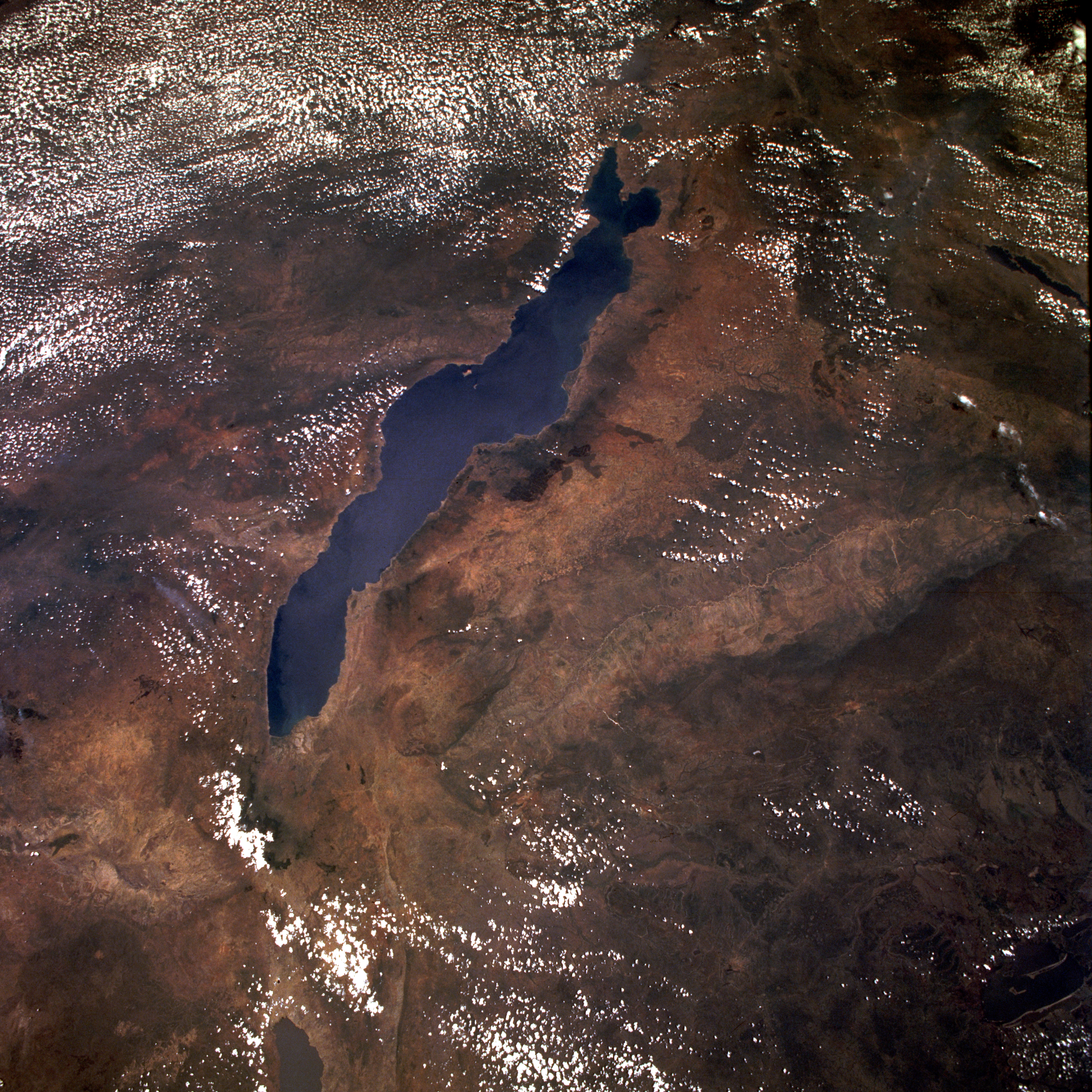 | 5 248 × 5 248 (21,23 MB) | Admin-allmultimedia (diskuse | příspěvky) | == Popis == GIGA08.11.2025 |
Tento soubor nemůžete přepsat.
Využití souboru
Tento soubor nepoužívá žádná stránka.
-NASAFlickr.jpg&oldid=4480)
-NASAFlickr.jpg)
-NASAFlickr.jpg&action=edit&redlink=1)
-NASAFlickr.jpg&action=history)
-NASAFlickr.jpg)
-NASAFlickr.jpg)
-NASAFlickr.jpg&action=info)