Antarctica 1912 edit.jpg
Jump to navigation
Jump to search

Velikost tohoto náhledu: 715 × 600 pixelů. Jiná rozlišení: 2 441 × 2 048 pixelů | 5 676 × 4 763 pixelů.
Původní soubor (5 676 × 4 763 pixelů, velikost souboru: 17,84 MB, MIME typ: image/jpeg)
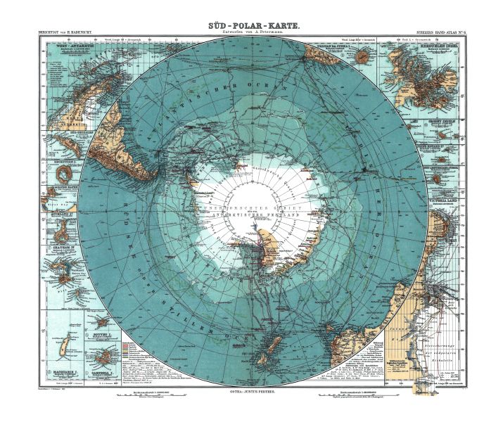
GIGANTICKÁ Mapa + Deutsch: Karte der Antarktis. Maßstab [ca. 1:40,000,000]. farbig, 34 × 41 cm.
- English: Map of Antarctica. Scale [ca. 1:40,000,000]. Col., 34 × 41 cm.
- Français: Carte de l'Antarctique, échelle 1:40 000 000e, couleur, 34 × 41 cm.
- Português: Mapa da Antárctica. Escala [ca. 1:40,000,000]. Cor., 34 × 41 cm.
- Date: 1912
- Source: Stieler Handatlas, 9. von Grund aus neubearb. und neugestochene Aufl. 8. berichtigter Abdruck. Verlag J. Perthes, Gotha, 1912.
- This map is available from the United States Library of Congress's Geography & Map Division under the digital ID g9800.ct000774.
- Author: Petermann, A.; Habenicht, H.; Böhmer, C.
+ pochází z Wikimedia Commons, kde má status – This image is in the public domain because its copyright has expired.
Historie souboru
Kliknutím na datum a čas se zobrazí tehdejší verze souboru.
| Datum a čas | Náhled | Rozměry | Uživatel | Komentář | |
|---|---|---|---|---|---|
| současná | 5. 11. 2025, 13:11 | | 5 676 × 4 763 (17,84 MB) | Admin-allmultimedia (diskuse | příspěvky) | == Popis == AlfaRomeo |
Tento soubor nemůžete přepsat.
Využití souboru
Tento soubor nepoužívá žádná stránka.